The source of the River Seine
The River Seine, often intertwined with the identity of Paris, originates far from the bustling city. It emerges from a site known as Source-Seine, nestled in the Plateau of Langres within the Côtes d’Or department of the Bourgogne-Franche-Comté region, at an altitude of 446 meters above sea level.

Winding its way across a span of 777 kilometers, the Seine traverses notable urban centers such as Troyes, Paris, and Rouen before flowing into the English Channel through a broad estuary flanked by the bustling ports of Le Havre and Honfleur.
Named after the Celtic deity Sequana, who was believed to inhabit its sacred source, the Seine carries a rich tapestry of cultural significance stretching back through the annals of time.
Above the spring’s inception, a man-made grotto erected in 1865 provides shelter to a statue embodying the nymph Sequana. Traditionally depicted as a graceful young woman standing upon a boat, the statue housed within this grotto is a replica of the original work by François Jouffroy, which depicted her reclining.
The vestiges of the Roman temple, once positioned near the source await potential excavation in the coming years. The archaeological museum of Dijon currently hosts a collection of various offerings and ex-votos unearthed from the surrounding area, offering insights into the region’s rich historical tapestry.
The River Seine in Paris
Flowing through Paris from east to west, the River Seine stretches for 13 kilometers at an elevation of precisely 26.72 meters above sea level.
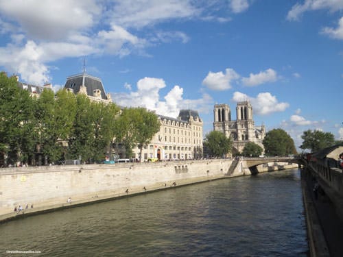
With widths ranging from 30 meters to 200 meters and depths from 3.4 meters to 5.7 meters, it forms a vital waterway for the city.
The River Seine is spanned by 37 bridges, among them 4 footbridges, which have stirred the creativity of poets and songwriters, inspiring odes to Parisian romance such as “Sous le Pont Mirabeau” and “Sous les Ponts de Paris.”
Its historical significance is evident from ancient times, attracting settlements since the Neolithic era and continuing to play a crucial role in transportation. The discovery of ancient barges in the Parc de Bercy, now housed at the Carnavalet Museum, serves as a testament to its enduring importance.
The Corporation of the Boatmen of Paris – Nautes Parisiens

The origins of the Corporation of the Boatmen of Paris can be traced back to the Celtic tribe Parisii, who long before Roman colonization settled on the Ile de la Cité, strategically positioned at the crossing of the River Seine and ancient north-south routes.
Proficient navigators on the Seine, the Parisii expanded their maritime activities following the Roman conquest.
The esteemed Nautes Parisiens corporation erected several monuments, notably the impressive Pillar of the Boatmen – Pilier des Nautes Parisiens, now housed in the Cluny Museum.
Flourishing during the Middle Ages through river trade, the corporation played a pivotal role in establishing the city’s earliest administrative structures. Their coat of arms, featuring a sailing boat navigating the River Seine, eventually became the official coat of arms of Paris.
Spanning the River Seine

In the 1st century AD, the Romans constructed the first bridge over the River Seine, rebuilding the wooden structure initially erected by the Parisii before the conquest.
Known as the Petit Pont, it stretches across the smaller arm of the River Seine, connecting the Ile de la Cité with Rue St Jacques on the Left Bank.
Recognized as Paris’ first and oldest bridge, it has preserved its original name despite undergoing several reconstructions throughout the centuries.
In addition to the Petit Pont, thirty-six other bridges have been built over the River Seine.
A once essential water supply source for Parisians
The Seine played a crucial role as a water supply source for Parisians over the centuries.

In 1608, a water pump called Samaritaine was installed beneath the Pont-Neuf, providing water to the Louvre until 1813. However, in medieval Paris, access to such infrastructure was lacking, and running water was virtually nonexistent. As a result, people either collected water directly from the river or purchased it from street vendors.
To address this issue, Napoleon initiated the construction of the Canal St Martin and Bassin de La Villette in the early 19th century, aiming to supply water to public fountains throughout the city.
Beyond its practical utility, the Seine also served as a natural recreational space for Parisians. Many would stroll along its banks or even swim in its waters.
Although swimming in the Seine was officially prohibited by decree in 1923, the tradition of enjoying the riverside continues with the annual Paris Plages event. During the summer months, locals and visitors alike can still relax and unwind in the heart of Paris along the banks of the Seine.
River Seine – once temperamental
The River Seine, once wild and unpredictable, was renowned for its ever-changing nature. In harsh winters, it would freeze solid, allowing pedestrians to traverse its icy surface on foot.

However, as spring arrived and temperatures warmed, massive blocks of ice would break free, often leading to bridge damage and flooding in nearby areas.
Throughout its history, the Seine has witnessed numerous significant floods, with notable occurrences in 358-59 AD and 582 AD.
The flood of 1280 resulted in the destruction of the Grand-Pont (Pont Notre-Dame), while the flood of 1296 was particularly devastating, submerging all of Paris’s bridges, which were then lined with houses.
One of the most memorable floods struck in 1910, lasting for nine days and causing the water level to surge by 9.50 meters between January 20th and 28th.
River Seine shaped Paris
The River Seine has wielded significant influence in sculpting the geographical features of Paris, shaping and reshaping the land over time.
Numerous islands and islets have emerged from its waters, each serving distinct purposes throughout history. Some, like those near Ile de la Cité, were consolidated to expand existing landmasses, while others contributed to the formation of new areas such as Ile St Louis. An example is the Ile Louviers, once near Ile St-Louis, which was connected to the right bank to create what is now Quartier Morland.

Further downstream, the imposing Ile aux Cygnes, an 890-meter-long embankment built in 1827, was instrumental in supporting the construction of three Parisian bridges. Initially named Ile Maquerelle, this island, nestled between the river and Rue de l’Université, was attached to the Rive Gauche.
Over millennia, natural processes have also left their mark on the River Seine, leading to changes in its course and the surrounding terrain.
One significant alteration occurred on the Right Bank, where a broad meander developed. Eventually, the river shifted course, leaving behind a sizable piece of land that gradually evolved into marshland, earning the area its name, Marais.
During the 11th century, the Knights Templar and monks of the Abbaye de St Martin-des-Champs undertook the monumental task of draining the marsh (marais), reclaiming the land for human habitation. For centuries, these religious institutions remained among the few settlements in the Marais region.
River Seine banks in modern days
In recent years, there has been a concerted effort to enhance and beautify the banks and quays of the River Seine, transforming them into pedestrian-friendly areas and verdant public gardens.
Certain stretches of the riverbanks have been permanently closed to vehicular traffic, providing serene spaces for leisurely strolls.
As you stroll along, you’ll encounter booksellers (bouquinistes)and inviting benches, perfect for pausing to take in the lively ambiance. Alternatively, you might consider embarking on a leisurely river cruise, offering a unique perspective of Paris from the water.
The River Seine itself has emerged as a sought-after destination, attracting visitors in search of a tranquil escape from the city’s hustle and bustle. Seize the opportunity to explore its peaceful banks and unwind amidst the serenity, away from the throngs of tourists.
Photos via Wikimedia Commons: Main source by Hubert DENIES CC BY-SA 3.0 – Flood 1910 Domaine public


