
Ypres Salient
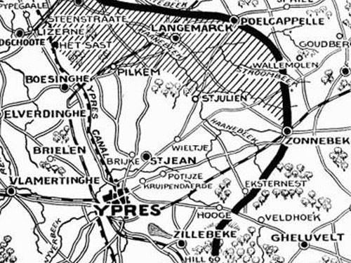
The Messines Ridge, located in the southern part of the Ypres Salient, was of vital importance during the conflict. Ypres was a crucial point, as it was directly in the path of the German advance through Belgium.
Strategically, control of Ypres was therefore essential for the Germans, as it guaranteed them direct access to the Channel ports, thus hindering the landing of British troops.
Despite German intentions, the Belgian army repelled their advance in October 1914. Breaching the dikes along the Yser, north of Ypres, effectively blocked German access to the western flank of the country.
Although Ypres remained undefeated, it was dangerously close to the front lines. German forces encircled the Ypres Salient on three fronts, making Allied troops vulnerable to their assaults.
The Gheluvelt Plateau, which extends along the southern perimeter of the Ypres Salient, constituted a formidable natural barrier, hindering Allied offensives from the east and preventing them from escaping the salient.
These strategic difficulties and the violent fighting that took place in the Salient thus resulted in considerable human losses.
Messines – Wytschaete Ridge
The Messines ridge extended as far as the village of Wytschaete, about 1.5 kilometres north along the N365 road leading to Ypres, and was therefore of strategic importance.
The German 26th Division captured the village of Messines (known as Mesen in Flemish) between October 31 and November 1, 1914.
Despite French attempts to retake it on November 6 and 7, 1914, the Messines Ridge remained firmly in German hands. Their defence lines indeed followed the ridge, giving them a commanding position to monitor the Allied positions in the valley below.
Wytschaete, affectionately nicknamed “Whitesheet” by British troops, became a focal point of the Allied efforts. Taking the Messines ridge was imperative, as control of the Gheluvelt Plateau would considerably shorten the front.
It would also prevent the Germans from advancing towards the British positions farther north and offer the Allies a clear view of the southern slope of the Menin Ridge.
Planning for the assault on Messines Ridge began in January 1916. However, it was postponed until June 1917 due to the German offensives at Verdun and the Somme, which required the Allies’ attention and resources.
Battle of Messines
The Battle of Messines took place on a formidable 14.5 kilometre front, extending from Hill 60 to Saint-Yves, near Ploegsteert, in a crescent formation that replicated the German occupation of the Ypres Salient.
Under the command of General Herbert Plumer, the British Second Army launched the offensive on June 7, 1917.
Considered a triumph of modern military strategy and tactics, this offensive marked a break with previous, fruitless frontal assaults conducted under heavy German artillery fire, which often resulted in tragic losses and failures.
Modern tactics exploited the enemy’s weaknesses. In this instance, the British took advantage of the absence of German reserves, which had been redirected towards Arras, and launched a swift and precise assault.
The offensive began with the detonation of 19 mines, annihilating German defensive positions and paving the way for the Allied advance.

After a brief but intense bombardment, the British infantry, supported by cavalry, tanks and aircraft, quickly launched its assault.
On June 7, their concerted efforts enabled British forces to advance more than 1.5 kilometres beyond Wytschaete and penetrate more than 3 kilometres into German territory.
The resounding success of the Battle of Messines encouraged the Allies to penetrate deeper into the German lines in the following weeks.
This strategic advance paved the way for a subsequent offensive, known as the Third Battle of Ypres or the Battle of Passchendaele. This offensive, which took place between July and November 1917, aimed to seize the ridge and village of Passchendaele (also called Passendale), northeast of Ypres.
Messines Ridge Cemetery
Located along the road to Wulvergehem, the Messines Ridge Cemetery houses the remains of 1,500 men who fell during the fierce fighting at Messines.

Unfortunately, two-thirds of them remain unidentified, their names erased by time and war. The cemetery is located on the Germans’ positions, that was marked as the Oyster Trench on British maps.
The troops of the New Zealand Division valiantly retook the village of Messines, but their victory was dearly won: 800 men lost their lives climbing the hill from the valley.
The New Zealand Memorial stands by the cemetery’s entrance, and pays tribute to the indomitable spirit and unwavering determination of the 827 officers and soldiers of the New Zealand Armed Forces.
New Zealand has decided to erect seven separate memorials in honour of its Missing in cemeteries established on the battlefields where they fell.
The New Zealand Memorial occupies a prominent place in the central alcove of the Wall of Remembrance for the Missing, ensuring that their names and sacrifice are forever recorded in the annals of history.
New Zealand Memorial Park
The New Zealand memorial park was erected on Messines Ridge, between the cemetery and the Island of Ireland Memorial Park.
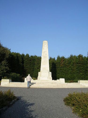
King Albert I of Belgium unveiled it on August 1, 1924.
An obelisk, engraved with the following dedication, marks its centre:
“In honour of the men of the New Zealand Division.”
“The Battle of Messines 7th to 14th June 1917”
“The New Zealand Division on the 7th of June captured this ridge and advanced 2000 yards through Messines to their objective on the Eastern side”.
Two bunkers, preserved in their war state, stands near the New Zealand Memorial Park.
Designed by architect Charles Holden, the Messines Ridge Cemetery New Zealand Memorial is topped by the Cross of Sacrifice.
The base of the monument is adorned with four panels, each dedicated to a regiment: the Maori, Auckland, Canterbury and Wellington regiments, in homage to their bravery and courage.
Not far from there, the CWGC Whytschaete Cemetery houses a Memorial to the courage and sacrifice of the soldiers of the 16th Irish Division.
Craters and bunkers
The farmland surrounding the Messines Ridge still bears the scars of the conflict, decades later.
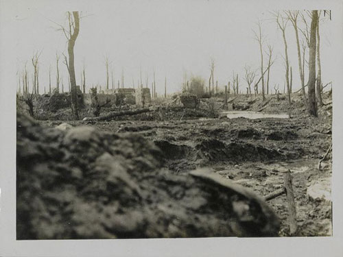
Imagine a desolate lunar landscape, crisscrossed with shell craters and engulfed by mud, an apocalyptic scene where nothing stands upright anymore. The once prosperous villages of Messines and Whytschaete lie razed, reduced to mere piles of rubble, while the remains of German and British trenches draw their lines on the countryside.
Intentionally preserved in their wartime state, many bunkers and craters serve as on-site monuments, honouring the memory of the soldiers who fell in the area.
Amazingly, the mine at La Petite Douve farm, southeast of Messines, remains strangely intact, its crater now submerged and abandoned, a persistent symbol of the destructive power unleashed on the day of the attack.
As you venture through the surrounding farmland, you will discover several other craters, each bearing its own story of devastation and loss.
From the vast Spanbroekmolen Crater, now known as the Pool of Peace, to the Peckham farm crater along the Kemmel road, and the Kruisstraat Craters along the Wulvergehem road, the scars of war are everywhere.
Another ruined bunker, in a field along the Wulvergehem road, near the Messines ridge cemetery, is believed to have probably served as an Allied stronghold, as its openings were oriented towards the German front lines.
Messines Ridge – Island of Ireland Peace Memorial Park
The Island of Ireland Peace Memorial Park is located on the southern slope of the Messines Ridge, along the road leading to Armentières. Its inauguration on November 11, 1988, was a landmark event, presided over by King Albert II of Belgium, in the presence of Queen Elisabeth and Mary McAlees, President of Ireland.
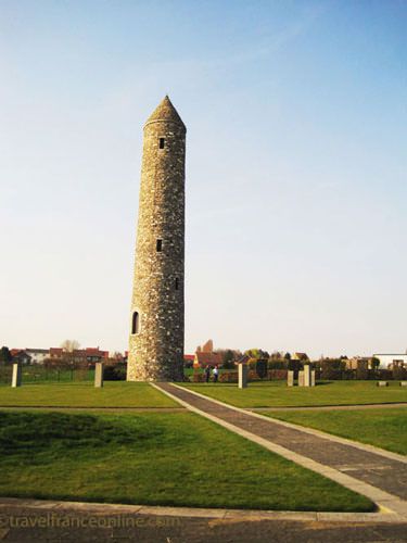
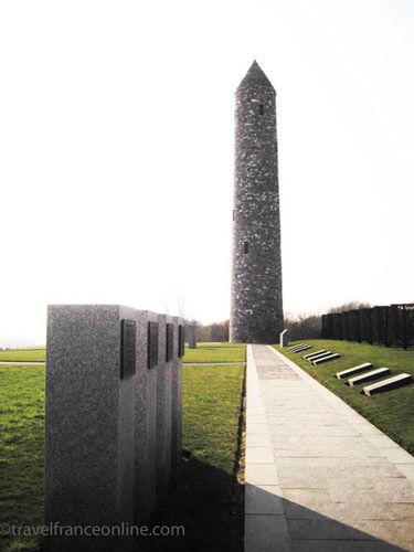
An imposing round memorial tower, a symbol of hope and reconciliation, stands in the centre of the park. Its construction was made possible thanks to the generosity of the Journey of Reconciliation Trust, supported by the unwavering commitment of the Messines community.
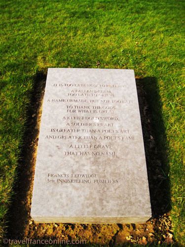
Several granite slabs, bearing moving quotes and verses written by Irish soldiers, line the path leading to the tower. Menhirs, engraved with the number of Wounded, Dead and Missing from the 37th Ulster Division, 16th Irish Division and 10th Irish Division, pay tribute to their memory. Additional standing stones commemorate the valiant battalions of Munster, Leinster, Ulster and Connaught, and inscriptions in Gaelic and English adorn the entrance to the park.
Two bronze plaques, placed at the southern end of the memorial park, recount the poignant stories of the battles of Messines and the Ypres Salient in 1917.
An imposing menhir stands at the southeast corner, a silent guardian of remembrance and reconciliation. It bears an engraved with a Peace Pledge:
“As Protestants and Catholics we apologise for the terrible deeds we have done to each other and ask forgiveness.
Remember the solidarity and trust between Protestant and Catholic soldiers when they served together in these trenches.”
The other side of the stone is engraved with the names of the Irish towns where the soldiers came from.
Belgium – Flanders
Island of Ireland Peace Memorial Park: Lat 50.759602 – Long 2.895337
New Zealand Memorial and Cemetery: Lat 50.765180 – Long 2.890767
Photos via Wikimedia Commons: Map Ypres Salient by “Current History” (New York Times) Public Domain – New Zealand Memorial Park by Amanda Slater CC BY 2.0 – German shell bursting in a water logged trench Public Domain


