Montagne Sainte-Victoire, a favorite of Paul Cézanne
The Montagne Sainte-Victoire is one of Provence‘s geological wonders, which gained worldwide renown thanks to the paintings of Paul Cézanne. This majestic mountain overlooks Aix-en-Provence to the west and the Pourrières plain to the east. Its highest point, the Pic des Mouches, rises to 1,011 metres.

The Montagne Sainte-Victoire is part of a limestone chain formed by tectonic activity linked to the formation of the Pyrenean-Provençal massif during the Eocene epoch. The subsequent uplift during the Oligocene, coinciding with the early stages of the Alps’ formation, caused the distinctive fold anticline rupture, thus sculpting the mountain’s distinctive silhouette. Geologists will tell you that the Montagne Sainte-Victoire is in constant motion, rising by 7 mm per year!
Its dominant ridge is surrounded by a wide variety of geological formations, including foothills, promontories, rounded hills, small basins, and valleys. It also boasts a quarry of pink marble, known as Marbre d’Aix, which is highly prized in construction and sculpture.
Victory Mountain or Windy Mountain?
Legend has it that in the 1st century BC, the Romans named the mountain Montagne de la Victoire (Victory Mountain) after their victory over the Germanic tribes on the plain of Pourrières.

Others suggest that the name comes from the Latin “venturus,” meaning “windy.” In Occitan, Montagne Sainte-Victoire is indeed called Mont Venturi, which would support this interpretation, given the Rhône Valley’s exposure to both the tramontane, a north wind from the Alps, and the mistral, which blows from the sea.
Thus, the name likely results from a combination of these two accounts!
At the beginning of the Middle Ages, with the Christianization of the region, Montagne de la Victoire was renamed Montagne Sainte-Victoire. Today, the locals affectionately call it La Sainte (The Holy One)!
Montagne Sainte Victoire, a landscape inhabited since the 3rd century BC
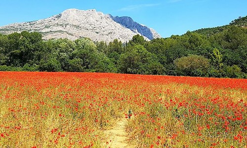
Montagne Sainte Victoire – Grand Site de France
In 1983, 6,500 hectares out of more than 30,000 of forest were officially designated a protected area. This designation made the Montagne Sainte-Victoire a true paradise for nature lovers, climbers, hikers, and mountain bikers, offering them access to hundreds of marked trails. However, a devastating fire ravaged more than 5,000 hectares of vegetation in 1989, leading to the creation of the Sainte-Victoire Massif Intermunicipal Syndicate., whose primary mission is reforestation.
Integrated into the Natura 2000 network, Sainte-Victoire Mountain provides a refuge for numerous bird species. It also received the prestigious labels of Grand Site Sainte-Victoire in 2000, and Grand Site de France in 2004, a distinction awarded by the Ministry of the Environment.
Department of Bouches-du-Rhône
Coordinates: Lat 43.535706 – Long 5.627514
Photos via Wikimedia Commons: Header by Imac.vincent CC BY-SA 4. – Mountain seen from Saint-Antonin-sur-Bayon by Mathieu BROSSAIS CC BY-SA 4.0 – Mountain and poppy field by Moony Ana CC BY-SA 4.0 – Painting by Paul Cézanne (1839–1906) Public domain