
Place Dauphine named after the Dauphin
Place Dauphine is located at the western tip of the Île de la Cité. It is nestled between the Palace of Justice (Law Courts) to the east and the magnificent Pont Neuf to the west.

The triangular-shaped Place Dauphine follows the shape of the island’s tip. At the beginning of the 17th century, the Île de la Cité looked very different, as it was considerably smaller and surrounded by several islets. Among these were L’Ile aux Juifs and L’Ile du Passeur, which were attached to the main island during the construction of the Pont Neuf and the creation of the Square du Vert Galant, the small public garden at the western tip of the island.
In 1607, Henry IV decided to develop a new square on the remaining islets and enclosed gardens of the medieval royal palace of the Cité. Place Dauphine was the king’s second urban development project after the prestigious Place Royale, now known as Place des Vosges. These two squares, the oldest in Paris, marked the birth of a new model of Parisian urban planning: orderly, harmonious and designed to combine prestige and daily life.
The Place Dauphine was inaugurated in 1607 and named to pay tribute to the dauphin, son of Henry IV and future Louis XIII.
Achille de Harlay, the developer of Place Dauphine
Henry IV commissioned the creation of the Place Dauphine to Achille de Harlay, president of the Parliament of Paris and a close collaborator.
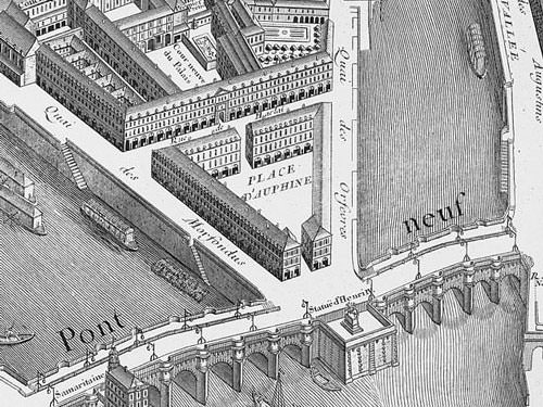
Harley was inspired by the Place des Vosges and had thirty-two houses built, arranged in symmetrical rows around the square. These dwellings, deliberately more modest than those in the Place des Vosges, were no less elegant: they had two stories, were built of stone and red brick, and topped with steeply pitched slate roofs. The ground floors housed shops, while the upper floors offered accommodation.
The square was thus enclosed and accessible via two entrances: one, still visible, led to the Pont Neuf; the other crossed a row of houses, on the east side, along what is now Rue de Harlay. This row was indeed demolished in 1874 on the orders of the architect Viollet-le-Duc, to open up the view of the new Vestibule de Harlay (hall), eading to the seat of the assize court of the Palace of Justice. The row of houses on the other side of the Rue de Harlay was destroyed after the Paris Commune of 1870, thus opening up the square on its eastern side.

Most of the remaining original houses have been altered over the centuries, often raised or completely rebuilt, but the overall harmony of the stone and brick facades has been preserved. However, only two original houses have remained intact: the pavilions that frame the passage connecting the square to the Pont-Neuf.
Despite these transformations, the atmosphere of Place Dauphine endures. The square indeed evokes a hidden village in the heart of the city: calm, green and intimate, lined with art galleries, cafes and restaurants, and particularly appreciated by lawyers and employees of the nearby Palace of Justice.
Benches installed under the trees invite you to relax and savour the charm of this historic square, which was officially classified as a historical monument in 1950.
Directions: 1st District – Ile de la Cité
Metro: Cité on Line 4
Coordinates: Lat 48.856512 – Long 2.342593
Photo via Wikimedia Commons: Plan Turgot by Louis Bretez, cartographer; Claude Lucas, engraver Public Domain


