
Fréhel Peninsula
The Cap Fréhel peninsula is one of the landmarks of the stunning Côte d’Emeraude (Emerald Coast).

The peninsula boasts an exceptional vantage point that provides magnificent views of surrounding coastal towns and villages, and beyond toward the Island of Bréhat, St-Brieuc, and the majestic fortress of St-Malo. On exceptionally clear days, you can even be see Jersey on the horizon!
Seagulls and cormorants soar gracefully above the 70-metre-high cliffs that plunge into the emerald waters, where sky, sea, and land seem to merge.
However, extreme caution is advised when walking along the cliffs, as the edge is neither safe nor protected!
Cap Fréhel, a bird sanctuary
Cap Fréhel is a bird sanctuary, a true paradise for nature lovers and birdwatchers!
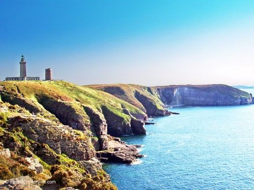
The trails leading to the tip of the peninsula and its two lighthouses are part of the GR34 long-distance hiking trail. To preserve this fragile ecosystem, you must remain on the wooden boardwalk marked by ropes. You will still appreciate the wild beauty of the peninsula while respecting the birds’ natural habitat.
This trail crosses lush moors dotted with heather, yellow gorse, and white flowers, whose colours change with the seasons, offering a spectacular visual display throughout the year.
Binoculars are essential, as Cap Fréhel attracts approximately 700 species of birds, both resident and migratory, which nest in the cliffs and surrounding islets. The only buildings on Cap Fréhel are the lighthouses and the panoramic restaurant perched on the Rocher de la Fauconnière. These minimal developments ensure that the natural environment remains largely untouched.
Cap Fréhel – lighthouse Tour Vauban
Cape Fréhel has been home to up to three lighthouses built over the centuries.
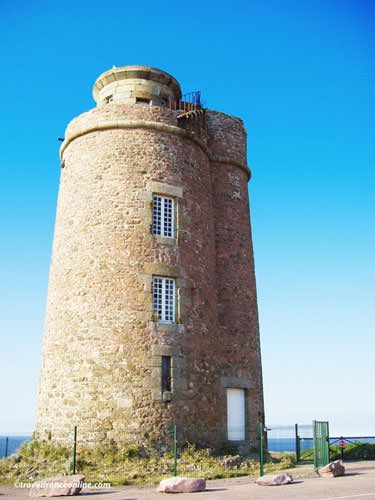
The first of these, the Tour Vauban (Tower), still stands today. In 1694, Marshal Vauban commissioned the construction of a series of coastal forts and watchtowers to protect the French coast from English incursions. In 1702, his deputy, Jean-Siméon Garangeau, chief engineer and director of fortifications in Saint-Malo, oversaw the construction of a 15-metre-high round tower.
Initially, this watchtower was only used during the winter months, with an open coal fire on the roof terrace serving as a beacon. It wasn’t until 1717 that it was illuminated year-round. In 1774, the rudimentary brazier was replaced by lamps equipped with sixty spherical reflectors, fueled by vegetable oil and housed in a lantern.
Lamps with eight parabolic reflectors were installed in 1821. These reflectors, which emitted light every 135 seconds, considerably improved the lighthouse’s range, making it visible at a distance of 21 nautical miles.
Lighthouse Tour Reynaud
In the 1840s, the architect Léonce Reynaud built a second lighthouse at Cap Fréhel. Reynaud, who was director of the prestigious Ecole des Ponts et Chaussées (School of Bridges and Roads) and director of the Lighthouses and Beacons service from 1848 to 1878, designed this lighthouse as a 22-metres-high octagonal tower.

He equipped it with a Fresnel lens composed of sixteen half-lenses that emitted a signal every 30 seconds. This powerful signal was visible for 40 kilometres. In 1875, the lighthouse was converted to mineral oil, but it was not electrified.
Further improvements were made in 1903 with the addition of a 0.70-metre focal length lens and four panels. This new system, powered by gasoline, emitted a signal every 10 seconds.
During World War II, the Germans used the lighthouse as a lookout tower. However, before withdrawing on August 11, 1944, they dynamited the structure.
Cap Fréhel’s current lighthouse
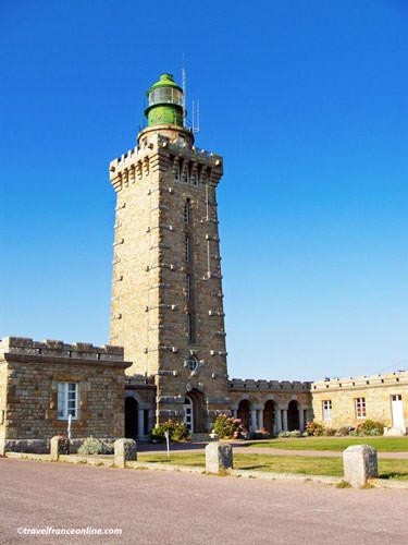
After the destruction of the second lighthouse, the old Vauban Tower lighthouse was put back into service until the inauguration of the third and current lighthouse.
Built between 1946 and 1950, this modern lighthouse stands 32 metres tall and stands in the centre of a U-shaped building.
The lantern, located 103 metres above sea level, overlooks the Bay of Saint-Brieuc, the Bay of Saint-Malo, and the surrounding area.
Remarkably visible up to 200 metres in thick fog and 100 kilometres in clear weather, it ensures the safety of ships navigating these waters.
Department of Côtes d’Armor
Coordinates: Lat 48.683475 – Long -2.318914


