
Thiers, Ville Basse and Ville Haute
Thiers is located in the Bois Noirs, the highest point of the magnificent and rugged Monts du Forez.
Its name, Thiers, which means “the house of the chief”, dates back to the Celtic era.

Thiers developed in two distinct districts: the Ville Haute (Upper Town) and the Ville Basse (Lower Town).
The Roman settlement of Thiernum extended along the valley, on the left bank of the Durolle, near present-day sites such as the Church of Saint-Symphorien, the Pré à la Foire and the remains of the abbey of Moutier. Located on the old road linking Lyon to Clermont-Ferrand, it was an important crossroads for trade between the inhabitants of the Limagne plain and those of the Monts du Forez. Historical texts from the 6th century mention Tigernum Castrum, the fortress located at the current site of Pré à la Foire.
A second church, dedicated to Saint Genesius, was built on the hillside, near the fortress of the barons of Thiers. The Arab invasions of the 8th century forced the inhabitants to take refuge on the rocky spur near the church, sheltered by the ramparts. This migration gave rise to a new village, marking the beginning of a significant demographic transformation in the region.

Over the centuries, the two villages continued to expand and evolve, leaving behind a rich historical heritage.
The Quartier du Moutier (district) extended along the left bank of the river (lower town), near the Moutier Abbey and the Saint-Symphorien church. Initially under the authority of the abbey, it came under the jurisdiction of the King of France from the 13th century onward.
Perched on the cliffs adjoining the Church of Saint-Genès and the fortress, the upper town, renowned for its historical charm characterised by its elegant half-timbered houses and narrow streets, experienced remarkable growth.
This is where you found the Quartier Saint-Jean, the cutlers district, administered by the barons of Thiers. In the 14th century, the barony of Thiers passed from the county of Auvergne to the duchy of Bourbon, marking a major turning point in its political affiliations. This dual jurisdiction persisted until the French Revolution.
Origin of the Thiers cutlery
Although Thiers cannot claim a great historical heritage, it has long been a thriving industrial and commercial centre.

It has indeed been renowned since the 14th century as the capital of cutlery (a title it shares with Laguiole in Aveyron). Surprisingly, the origins of Thiers’ metallurgical expertise remain a mystery.
The cutlers overcame difficulties such as limited access to essential resources, sandstone for millstones and the scarcity of local iron ore. They harnessed the abundance and power of the Durolle water to operate the wheels of mills and forges strategically built in the depths of the canyons.
They also exploited the vast surrounding forests to produce the charcoal needed to fuel their machines.

They sourced iron ore from the Dauphiné region and sandstone from Haute-Loire.
Cutlery experienced constant growth and reached its peak in the 17th century. At that time, a significant portion of Thiers’ production was exported to markets in the Mediterranean basin, Europe, South Africa, and even South America.
This strong commercial network also fostered the development of related industries, such as tanning and paper-making.
Thanks to its flourishing industries and extensive trade relations, Thiers established itself as the most prosperous and influential city in Auvergne during the 16th and 17th centuries.
Thiers and the river Durolle
Perched on the cliffs overlooking the Durolle, the upper town of Thiers benefits from a remarkable setting, that of a “suspended town”.

Carved by the tumultuous river, the narrow canyons that surround it have inspired evocative place names that still endure today, such asBout du Monde” (End of the World) and “Creux de l’enfer” (Hell’s Hole).
On the opposite bank, the city extends across the Limagne plain, all the way to Clermont-Ferrand.
Although Thiers is an ancient city, its role in French history has been relatively minor, which explains its limited architectural heritage.
Nevertheless, the few religious and medieval buildings it possesses are classified as historical monuments.
Thiers, the French capital of cutlery
The cutlers of Thiers specialised in the manufacturing of regional folding knives, including the renowned Laguiole knife. The legacy of Thiers’ flourishing industrial past is also reflected in the names of its streets: Rue de la Coutellerie (Cutlery St) – Rue des Forgerons (Blacksmiths St) – Rue des Usines (Factories St) – Rue de l’Industrie (Industry St).

The cutlery industry reached its peak in the 19th century, when half of the knives used by French peasants were made in Thiers. Faced with increasing demand, production became fully industrialised, with each stage of manufacturing being delegated to specialised workshops. This decentralised approach encouraged the proliferation of numerous small workshops throughout the city and its surrounding villages. The knives produced in series in Thiers thus ended up on markets all over the world.
At the end of the 19th century, cutlers and forges left the banks of the Durolle to settle in the plain, the advent of electricity offering an alternative source of energy. Today, the cutlery industry in Thiers is more flourishing than ever, renowned for its unparalleled know-how and expertise.
With nearly 200 workshops, Thiers produces more than two-thirds of the national production of kitchen, pocket and table knives. Since 1994, the blades from Thiers have borne a distinctive mark: a T engraved in a square, introduced by the local cutlers’ guild. For lovers of fine knives, the annual Art Knife Festival, held in May, offers a fascinating glimpse into the world of handcrafted cutlery.
La Vallée des Usines
The Valley of Factories, the industrial heart of Thiers, is in the Creux de l’Enfer (Hell’s Hole) canyon. Various industries, such as cutlery, paper-making and tanning, developed there at the beginning of the 19th century.
However, these imposing, emblematic workshops closed at the end of the 19th century but have since been restored. These include the Usines du Faux Martel, l’Usine du Pont de Seychalles, and L’Usine de la Croix de Fer.

There were are the paper mills of L’Ilot Navarron, the Propriété de Crospailhat, and the Forges Mondières, the latter of which remained in operation until 1980 and was later classified as a historical monument.
Built on the site of a 14th-century forge, the L’Usine du Creux de l’Enfer was transformed in 1988 to house the Contemporary Art Centre.
L’Usine du May, another remarkable building erected at the end of the 19th century, is a perfect example of industrial architecture. Classified as a historical monument in 2002, it became La Maison de l’Aventure Industrielle (House of Industrial Adventure) in May 2009. This cultural space offers a captivating glimpse into the Vallée des Usines’ past and present architectural and industrial heritage.
The setting is simply breathtaking! You can easily imagine the cutlers of yesteryear taking the Chemin des Rochers, a path carved into the cliff-side, to get to the factory.
Thiers, the historic city
Thiers was partly destroyed during the Hundred Years’ War and the Wars of Religion, but rebuilt in the 15th and 16th centuries.
Today, the old upper town, on the hillside near the Church of Saint-Genès, is classified as a protected area.

It is bordered by the Rue de la Terrasse du Rempart, which offers exceptional views of the Monts Dore, Clermont-Ferrand and the Limagne plain.
The Rue de la Conchette follows the outline of the 15th-century ramparts. It was named after the Conche Fountain, which has since disappeared, and it is lined with 16th-century patrician houses.
The Rue du Bourg, in its extension, is the oldest thoroughfare in Thiers. It follows the contours of the 12th and 13th-century ramparts, and it is lined with several picturesque houses, including a superb Flamboyant Gothic residence at No. 10.
The narrow, steep Rue du Pirou is lined with half-timbered houses dating from the 15th, 16th, and 17th centuries. The Maison du Pirou, commissioned in the 15th century by the Duke of Bourbon, now houses the tourist office. This splendid private mansion stands out by its pointed gables and its facade adorned with wooden trellises, and overlooks the Place du Pirou, formerly the seat of the court.
The house at No. 11 is known as the Maison des Sept Péchés Capitaux (House of the Seven Deadly Sins). This name comes from the sculpted heads that adorn the beam supporting the first floor, each representing a deadly sin: sloth, anger, envy, gluttony, lust, avarice, and pride. The facade of this remarkable residence is, quite rightly, classified as a historical monument.
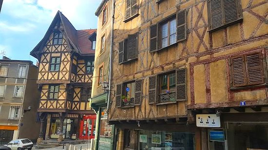
One of the most intriguing architectural features of Rue du Pirou is the Pedde du Coin des Hasards, an old structure adorned with ornate woodwork that spans the alley. This building replaced the old Charrier Gate of the fortress.
The facades of the houses lining Rue de la Coutellerie feature original sculptures. The facade of No. 14 is adorned with a wooden trellis evoking scallop shells and features statuettes of men and a woman in unusual positions.
However, the most mysterious facade is that of the Maison de l’Homme des Bois (House of the Woodman), at No. 21. This 15th-century dwelling is adorned with strange wooden sculptures, including a figure dressed in animal skins and leaning on a staff with a head-shaped pommel.
The Cutlery Museum was founded in 1983 at Nos. 23 and 58, in a former cutlery workshop and the former aldermen’s house. This museum showcases six centuries of cutlery tradition through classic and interactive exhibits.
Finally, farther down, Rue Anna and Rue des Remparts run along the outer perimeter of the old fortifications.
St-Genès Church
The Church of Saint-Genès is dedicated to the Christian martyr Genes of Mycenae.
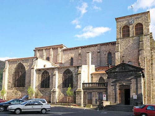
Legend has it that he was beheaded on the Rocher Saint-Genès, located farther down the slope, below the cemetery of Saint-Jean.
A first church, built in the 6th century, became an important pilgrimage centre. The current Romanesque church replaced it in the 11th-12th centuries. The Church of Saint-Genès has undergone numerous modifications and expansions over the centuries, including the addition of side chapels.
One of these chapels houses an altar dedicated to Saint Eligius, patron saint of cutlers. Restoration work carried out over the last two centuries has uncovered mural paintings dating back to the church’s origins.
St-Jean Church – Quartier St-Jean

The church of Saint-Jean is located below the Church of Saint-Genès, on the rocky spur where, according to legend, Saint Genesius suffered martyrdom.
This church, now abandoned, was built in the 15th century and then completely rebuilt to serve the parishioners of the Quartier Saint-Jean, the cutlers’ district.
The church was fortified and integrated into the ramparts built during the Wars of Religion in the 16th century.
Of these fortifications, only vestiges remain today: the Passet, a steep path descending towards the Durolle, the remains of a vaulted gate and the imposing fortified bell tower.
St-Symphorien Church – Quartier du Moutier
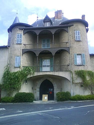
The Church of Saint-Symphorien stands on the banks of the Durolle River, where the Quartier du Moutier (lower town) initially developed.
Legend has it that the first church was built in the 6th century on the spot where a worshipper is said to have deposited three stones stained with the blood of the martyr Symphorien.
This church, remodelled in the 11th century, was attached to the Benedictine Abbey of Moutier, which was founded in the 8th century. This abbey was ravaged by a flood in 1707 and closed permanently a few years later.
Today, the only vestiges are the two towers that frame the gate of the 15th-century abbot’s manor.
The Orangerie du Quartier du Moutier, opposite the church, was originally part of a private mansion built in 1877 by a wealthy bourgeois.
Le Jacquemart
Finally, as you head towards the historic district, you will cross Place Antonin Chastel and discover Le Jacquemart.

This impressive metal clock depicts a 2.10-metre-tall blacksmith striking an anvil, accompanied by a waterwheel symbolising the vital energy of the water that powers his forge.
Le Jacquemart chimes every hour from 9 a.m. to 9 p.m., serving as both a functional clock and a public artwork.
The symbol of Thiers’ industrious spirit, it was designed by artists Michel and Jean-Pierre Hartmann and inaugurated on April 12, 2008.
Department of Puy-de-Dôme
Coordinates: Lat 45.856690 – Long 3.547297
Credits: Photos PapouPoustache – Photos via Wikimedia Commons: St-Genes Church by Jastrow CC BY 2.5 – Logis abbatial du Moutier by Sylenius CC BY-SA 3.0 – Maison de l’Homme des Bois and Maison du Pirou and Usine du May by Lethiernois CC BY-SA 4.0 – Maison des 7 péchés capitaux by Bdenis CC BY-SA 3.0 – St-Jean Church and Cemetery by Pierre Contie CC BY-SA 4.0 – Header Pont du Navire by Calips CC BY-SA 3.0


