
Les Grottes de Perrier, a geological marvel shaped by volcanic activity
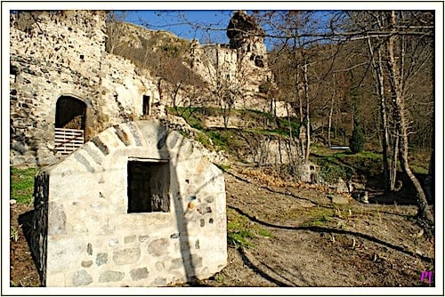
Nestled in the cliff face of the Perrier Plateau, the Grottes de Perrier (Caves), also locally known as the Village des Roches (Rocks), comprise a series of troglodytic dwellings.
The Perrier Plateau was formed during the eruption of the Monts Dore volcano, a process marked by the interaction of fluvial deposits and volcanic activity.
These deposits, composed of mud, sand, and gravel, mixed with lava flows and pyroclastic debris from the volcanic eruptions, create a unique landscape. Geologically called a lahar, this phenomenon of mud-flows and volcanic debris contributed to the formation of the vast river valley. Over time, the Allier River continued to sculpt the terrain, carving out the plateau and revealing the impressive 100-metre-long cliff, dotted with complex caverns that would become the Grottes de Perrier.
Grottes de Perrier converted into troglodytic habitat
The rock shelters in the Perrier caves show evidence of human occupation spanning millennia. Prehistoric artefacts discovered on the site indeed indicate that these rock shelters were indeed inhabited since the Neolithic period.
Much later, during the Celtic era, the Arverni tribe expanded and adapted these natural caves into dwellings. This evolution is reflected in the local dialect, where “perières,” meant excavations or artificial caves, and evolved into “perriers.”
In the 10th century, descendants of the Arverni built the first houses in the plain below. However, the turmoil of the Hundred Years War in the 15th century forced them to take refuge once again in the Grottes de Perrier.

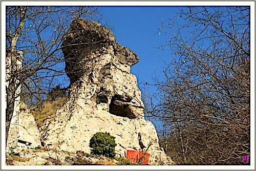
They fortified the rock shelters with a rampart and transformed a unique geological formation, a fairy chimney, into a watchtower known as the Tour de Maurifolet.
Historical documents from the late 16th century reveal that several hundred villagers inhabited then the Grottes de Perrier. However, they began to migrate down to the valley in the following century, and founded the present-day village.
Despite this relocation, around twenty families still lived in these troglodytic dwellings in the Village des Roches until the end of the 19th century, with the last inhabitant leaving at the end of the Second World War.
The Village des Roches troglodytic dwellings
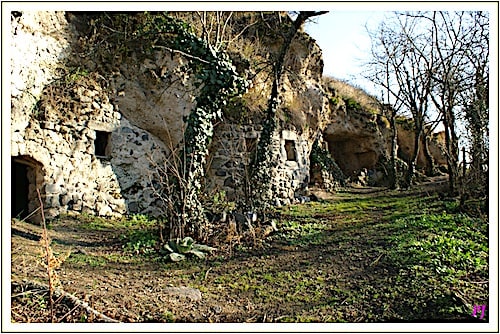
The cave dwellings of the Grottes de Perrier are ingeniously arranged on two levels of the cliff. The houses are located in the upper sections, while the cellars were carved into the cliff face at its base.

Paths ran along the edge of the cliff, connecting these dwellings, and staircases and ladders facilitated movement between the different levels. Vegetable gardens and vineyards were, of course, located at the bottom of the cliff.
Over the centuries, the villagers continually adapted their dwellings to their changing needs. The first inhabitants enlarged and modified the natural rock shelters, which were generally narrow vaulted rooms about 75 cm wide.
But, subsequent generations expanded their living spaces, abandoning the semi-cave dwellings and opting for masonry or timber extensions built against the cliff. Many of these dwellings retain visible traces of human occupation, such as chimneys, partitions, carved furniture, and cavities once used for lamps.
Grottes de Perrier, a protected site part of Natura 2000
The Grottes de Perrier site is not only the largest troglodytic in Auvergne, but it also possesses exceptional ecological value and has been protected since 1930.
It is also part of the Natura 2000 network, which aims to preserve natural habitats and species in harmony with human activities.
Located on the Perrier plateau, the area is home to a rich and unique array of flora and fauna, particularly those associated with dry grasslands.
To address concerns related to the site’s preservation, the Association for the Preservation of Perrier’s Heritage was created in 1997. Its mission includes both slowing the site’s degradation and implementing restoration measures. Thus, despite ongoing natural erosion, the site remains accessible to visitors via marked trails, offering the opportunity to explore the 300 rock shelters uncovered to date.
Department of Puy-de-Dôme – Perrier – Auvergne region
Coordinates: Lat 45.548214 – Long 3.200267
Credits photos: Jean Piludu @cpauvergne


