
La Roche de Solutré, classé Grand Site de France
La Roche de Solutré is a geological marvel, designated a Grand Site de France. This imposing limestone promontory rises 493 metres above the limestone Saône plain.
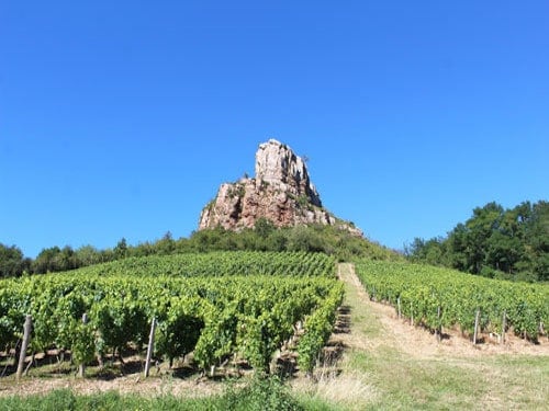
It boasts exceptional panoramic views of the vineyards of Solutré-Pouilly and the Mâconnais region, as well as Bresse, Dombes, and even Mont Blanc on a clear day!
The villages of Solutré-Pouilly and Mont de Pouilly lie to the south, while to the west, the ancient Roman road winds through vineyards and groves. To the north, you can see the Roche de Vergisson, another limestone spur.
Archaeological discoveries made at the foot of La Roche de Solutré attest to human occupation during the Palaeolithic era.
The monks of Abbey of Cluny planted the first vines in the Middle Ages, and today the region boasts three renowned wine appellations. Chardonnay thrives on this unique terroir, giving rise to the renowned Pouilly-Fuissé, Saint-Véran and Mâcon-Villages.
La Roche de Solutré, a rare geological phenomenon
La Roche de Solutré is a remarkable geological phenomenon that was classified as a protected site on May 2, 1930, due to its archaeological and geological significance. It was designated a Grand Site de France on May 26, 2013.
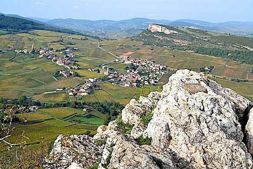
This promontory is the result of a rare geological process dating back to the Mesozoic era, when a warm sea covered the region. As a result, the surrounding terrain is primarily composed of deposits of fossilised marine organisms.
However, La Roche de Solutré is an exception: it indeed consists of fossilised coral reefs formed approximately 160 million years ago. During the Tertiary Period, the emergence of the Alpine mountain range exerted immense pressure on the landscape, leading to profound transformations. While the softer rocks succumbed to erosion, resistant formations, such as La Roche de Solutré, withstood the onslaught and rose above the surrounding plain.
This geological anomaly has fostered the development and isolation of unique flora and fauna, exemplified by the presence of Pelouses Calcicoles – Calcicolous Grasslands at its summit. These plants thrive exclusively in soils rich in calcium carbonate and cannot survive in acidic environments, making them unique to the site. Consequently, the Roche de Solutré has been included in the Natura 2000 network to preserve its exceptional biodiversity.
Solutrean Culture
Traces of human occupation dating back 55,000 years have been discovered at the foot of La Roche de Solutré, in the area known as Cros du Charnier.
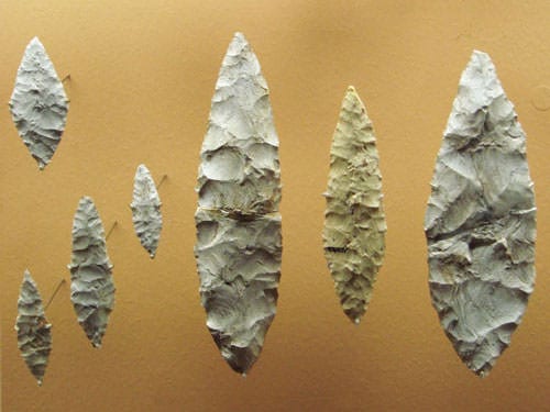
The first excavations, undertaken in 1866, yielded a remarkable collection of finds, including numerous bones of horses, aurochs, bison, and mammoths, as well as countless flint tools and artefacts. These discoveries shed light on the way of life of the Palaeolithic nomadic tribes who once inhabited the region. Considered one of the most important archaeological sites in Europe, the site gave its name, Solutrean , to this particular Palaeolithic culture.
Excavations continued until 1925, unearthing nearly 70 human skeletons. However, subsequent research revealed that these bones were much more recent than initially thought, originating from a necropolis dating back to the Early Middle Ages. This discovery also shed light on the site’s name: “Cros,” meaning rock, and “Charnier,” meaning ossuary.
Later excavations in the surrounding area also unearthed the foundations of two neighbouring Gallo-Roman villas. One of these estates, known as the Solustriacus estate, gave its name to the village of Solutré. The Departmental Archaeological Museum of Prehistory, established by the Saône-et-Loire General Council, was inaugurated in 1987. Located beneath a green dome, it blends harmoniously into the surrounding protected site.
Department of Saône-et-Loire
Coordinates: Lat 46.299167 – Long 4.719167
Photos via Wikimedia Commons: Photo#1 and Header by Chabe01 CC BY-SA 4.0 – Solutrean tools by World Imaging CC BY-SA 3.0 – Photo2 by Babsy CC BY-SA 4.0


